


Cacti, Crags and Cranes III
Into the heart of the southern desert

Part 3: Carlsbad to Big Bend, Texas
There are four desert provinces in North America, and our first road trip of 2023 took us through three of them. Each has its distinctive climate and suite of plants and animals, although there is a fair amount of overlap at the edges, and as we headed south from Carlsbad on our way to West Texas, Leslie and I pushed deep into the Chihauhaun Desert.
The Great Basin Desert is the most northerly of the four, and the only one we missed during our most recent journey. Stretching from central Oregon nearly as far south as Las Vegas, and from the Eastern slope of the Sierra Nevada in California to the western edge of the Wasatch Range in Utah, it is temperate and receives a fair amount of precipitation in the winter. Given that it occupies Basin and Range country, its elevation varies widely; among its signature plant communities are sagebrush steppe and the pinyon pine-juniper woodland that blankets its many mountain slopes.
The Mojave Desert is the smallest and driest of the four, located mainly in southeastern California but reaching into Nevada and Arizona as well. Its indicator plant species is the Joshua tree, and we traversed it on the first leg of the trip. At the Arizona border, we crossed the Colorado River into the Sonoran Desert, which I wrote about in the first installment of this travelogue, heralded by the appearance of its signature cactus, the giant saguaro. The transition was almost comically sudden: Joshua trees and no saguaros on the California side of the river, then no Joshua trees and saguaros everywhere on the Arizona side, as if the two states had a botanical immigration pact prohibiting their native plants from straying into each other’s territory.
We’d been on the edge of the Chihuauan Desert when we visited Chiricahua National Monument (described earlier), but crossing into Texas put us in its heart. It’s the largest North American desert, much of it lying in Mexico, and it is unusual among them because the majority of its precipitation falls in the summer, when monsoon moisture sweeps in from the Pacific and across the Gulf of California. For all that, it’s still dry and hot, and its botanical diversity is relatively low, signature plants being the awkwardly proportioned soaptree yucca and lechuguilla, a type of agave found nowhere else. It’s a tough plant with wickedly sharp leaves, sometimes forming dense knee-high thickets.
Lechuguilla’s common alternative name is “shin dagger.” Which tells you all you need to know about what it’s like to wander off trail in Chihuahuan country.
Exploring the reef
Our initial stop in Texas was Guadalupe Mountains National Park. We had originally intended to visit Carlsbad Caverns National Park first, since it was on the way, but the weather forecast — something we’ve learned to pay close attention to on these long trips — indicated the return of punishing winds the following day. We figured we’d spend that time hiding out underground, and instead prioritize hiking in Guadalupe’s McKittrick Canyon while the good weather lasted.
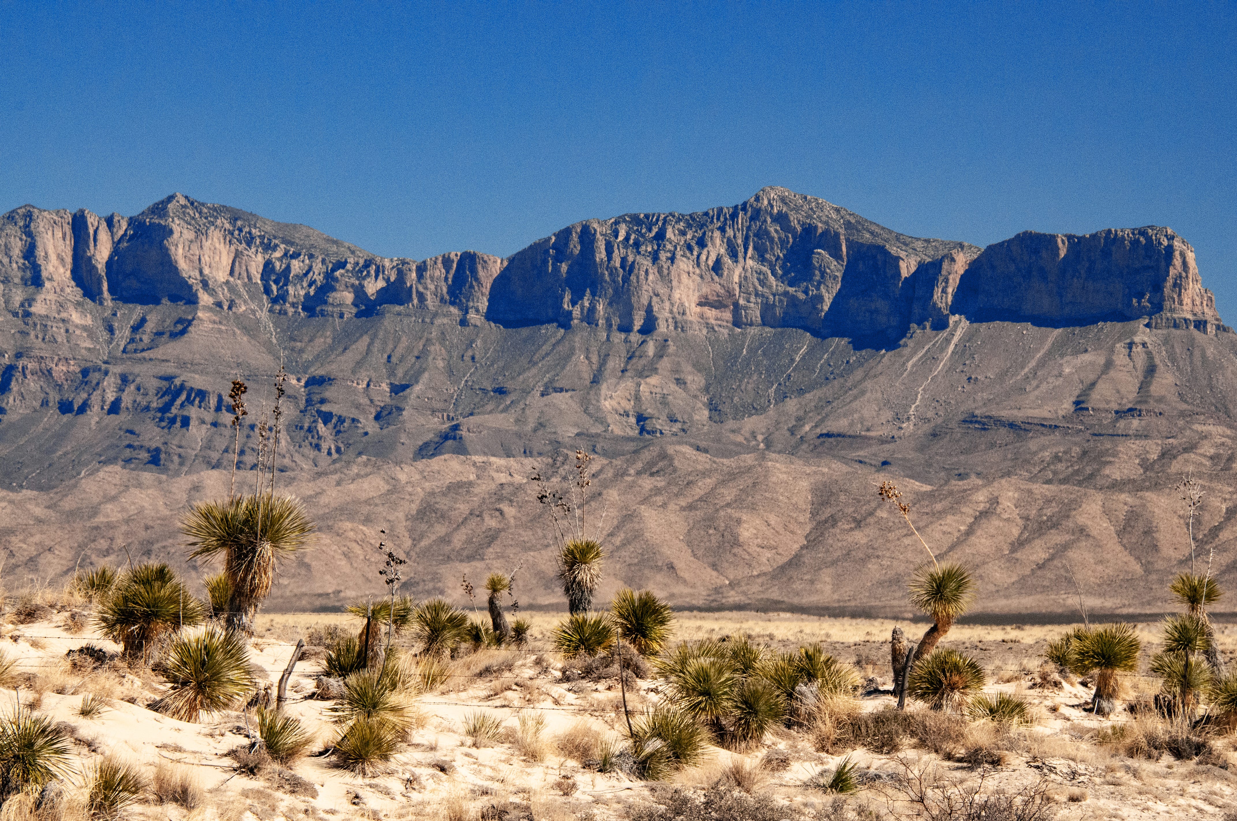
Until this point in our trip, the mountains we had been encountering were various flavors of volcanic in origin. Not so the Guadalupes. They are the product of a marine environment, the fossil remains of a vast reef that formed beneath the same tropical Permian Sea that laid down the gypsum deposits responsible for the sparkling dunes of White Sands National Park. The entire formation, called the Capitan Reef, is a limestone horseshoe 400 miles long that’s mostly buried.
The segment uplifted and exposed by erosion in Guadalupe National Park stretches 40 miles, nearly to the town of Carlsbad, New Mexico. (Other isolated bits are exposed in the nearby Apache Mountains and Glass Mountains.) The Guadalupes rise thousands of feet above the surrounding desert and include the highest point in Texas, 8,751-foot Guadalupe Peak. It’s mind-boggling to consider that the massive formation is the product of calcareous sponges, algae and other lime-secreting organisms, living and dying and piling up between 260 million and 270 million years ago. Once again, we found ourselves in a landscape that severely tests the human sense of time, and of what living organisms can do given enough of it.
Surrounded by sparsely vegetated desert, McKittrick Canyon is a lush oasis, watered by a spring-fed creek that flows above ground year-round in some reaches. The trail we hiked follows the course of the streambed, passing through typical Chihuahuan assemblages of spiny plants but also woodlands of alligator junipers, Texas madrones, willows, gray oaks, bigtooth maples and ponderosa pines. Above it all reared precipitous cliffs more than a thousand feet high.
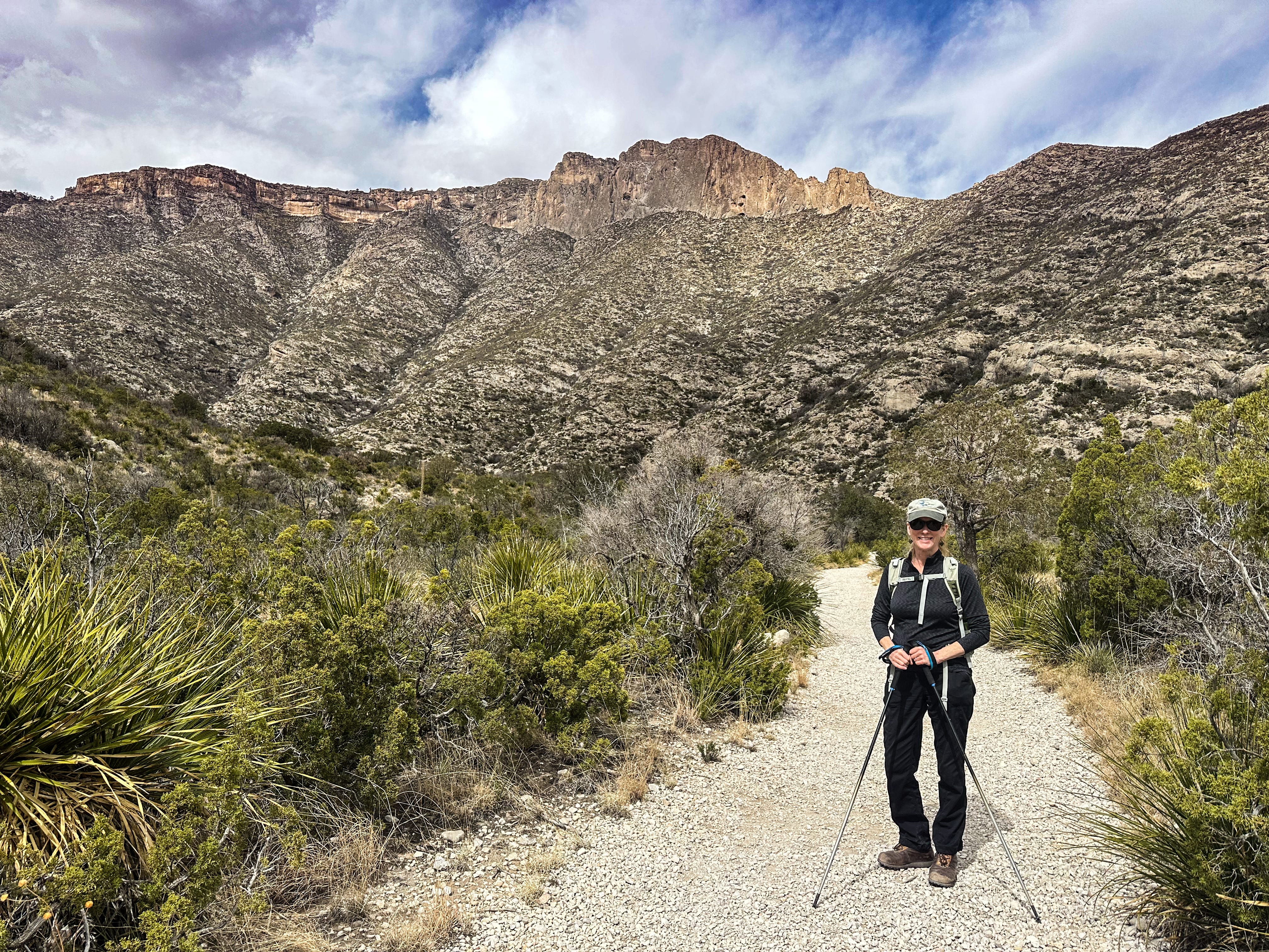
We hiked in about 2.5 miles, and stopped for a picnic lunch at a historic cabin that was once the home of oil geologist Wallace Pratt, who bought up land in the canyon in the 1920s and eventually donated 6,000 acres to the federal government to serve as the nucleus of a national park. It had been cloudy and windy when we began the hike, but the canyon walls provided shelter, and as we dined, the sun came out to warm us.
Enjoying the temporarily pleasant conditions, we headed back to the van and made our way to the park visitor center, where the wind already had picked up considerably. A ranger informed us that a few days earlier (the day of our blustery drive from Chiricauhau to Las Cruces), gusts had reached 90 mph and overturned a Class A motor home in the visitor center parking lot. Guadalupe Mountains is notorious for its winds — the park website posts photos of airborne tents as a caution to campers — but that was a sobering image to ponder as we drove to our campsite on a nearby patch of privately owned desert.
Underground
Sure enough, the wind the next day was intense, buffeting Next Chapter ferociously as we backtracked to Carlsbad Caverns National Park, just over the state line in New Mexico. The conditions made it clear that planning to spend the day underground had been the right call.
Our drives back and forth over the state line revealed an odd quirk in the configuration of time zones in this part of the country. Almost the entire state of Texas is in the Central Time Zone, whereas New Mexico is in the Mountain Time Zone. Generally, time zone boundaries follow state boundaries. Not so here.
The divide between the Mountain and Central zones does follow the state line along rectangular New Mexico’s eastern edge, but along the state’s southern boundary the time zone divider doglegs into Texas where the highway between Carlsbad Caverns and Guadalupe Mountains crosses from one state to the other. It then follows the boundary between Hudspeth and Culberson counties due south until it hits the Rio Grande, leaving a triangular chunk of Texas (containing both El Paso and Guadalupe Mountains National Park) marooned in the Mountain Time Zone with all of New Mexico.
The principal result of this was total confusion on the part of our smartphones, my GPS-connected wristwatch, and the van’s GPS-linked dashboard clock. Even though we were not moving between time zones as we traveled back and forth between states, our timekeeping devices kept unpredictably and inconsistently jumping back and forth an hour, all of them disagreeing among themselves about what time it actually was at our location.
Normally, this would not have been a real problem, but to enter Carlsbad Cavern, you need a timed-entry reservation. And at the time, we didn’t know about the mismatch between state lines and time zone; that was something we figured out later by examining paper highway maps (yes, we still carry those). In other words, we didn’t know when we were.
In the end, it didn’t matter. We showed up early at the park visitor center to pick up our tickets, and were able to move our reservation ahead (hooray for traveling in the off season). To spend as much time as possible out of the wind, we ate lunch in the visitor center cafeteria, thoroughly explored the exhibits and gift shop, and then headed to the trailhead for the natural entrance to the cave. It’s possible to simply ride an elevator down to the main cavern from the visitor center, but that seemed unsporting, and we would have missed experiencing the transition from light to darkness.
The trail descends 750 feet in about a mile, which is a pretty serious gradient, and our legs were rubbery by the time the route leveled out. We spent a couple of hours wandering among the spectacular features in the enormous cave system, which is extravagantly beautiful but also delivers another lesson about the unconformity between human and geologic scales of time.
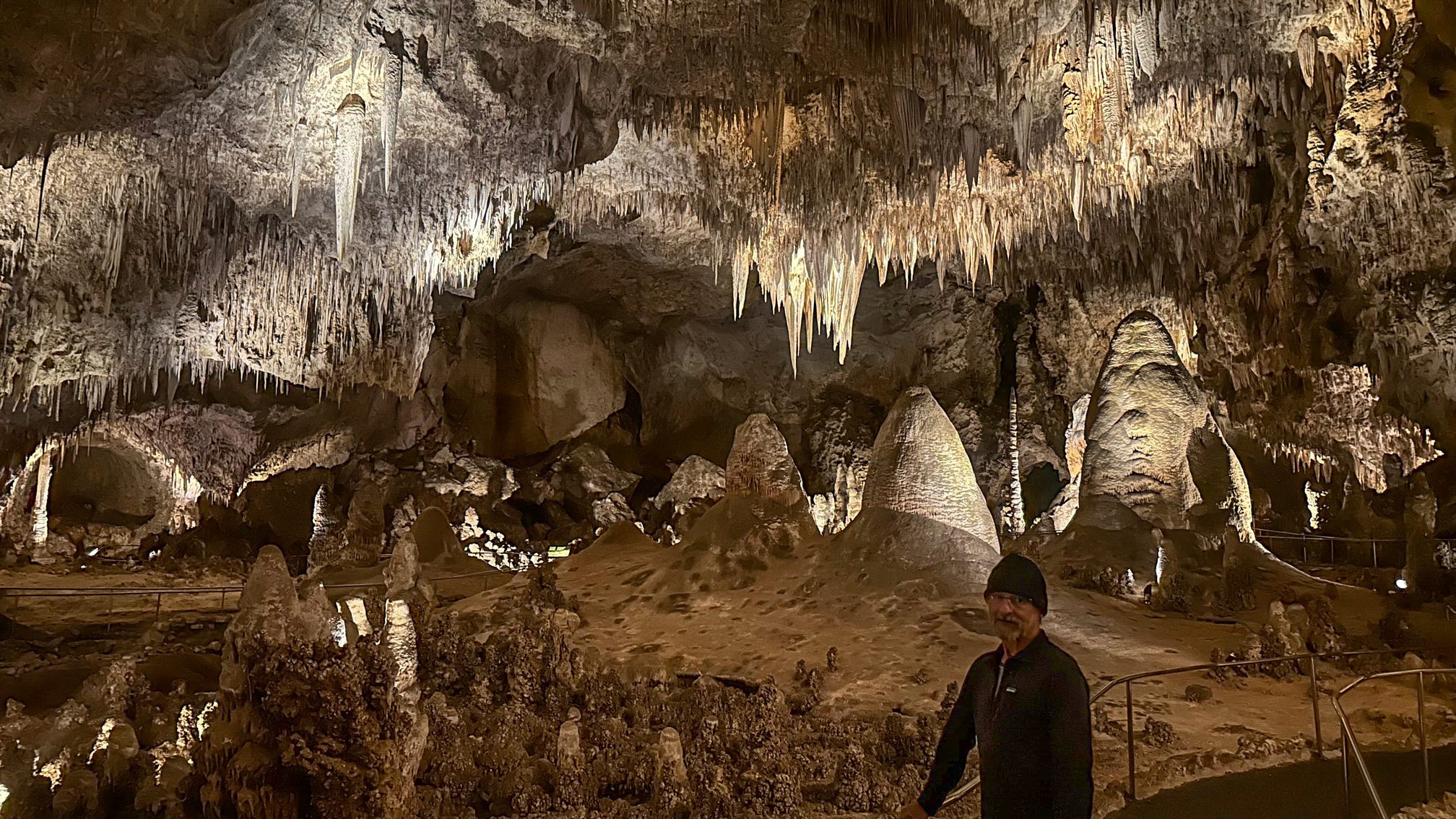
Carlsbad Cavern is hollowed out of the same Permian Sea reef that forms the Guadalupe Mountains, so it shares with them the same deep-time genesis. But all of the surreal cave features — stalactites, stalagmites, columns, draperies and countless others — were formed one drop of water at a time, each drop depositing a minuscule amount of calcite. It creates a sort of temporal disorientation as you try to wrap your ahead around the difference between 270 million years (the time since the reef began to form), 12 million years (the time it took to create the reef), and 500,000 years (the time it’s taken for the cave decorations to reach their current state).
For the record, we took the elevator back to the surface, 750 vertical feet above. We’re not masochists.
Into the Borderlands
After a final night at our rented campsite, we pushed further south, bound for Big Bend National Park. Along the way, we stopped in another of the Southwest’s quirky little towns: Marfa, which was born as a water and freight stop on the railroad (which bisects the town), boomed during World War II as thousands of would-be pilots arrived to train at the Marfa Army Air Base, gained minor fame as a film location (Giant, No Country for Old Men), and has now remade itself as an arts and culture hub in the unlikeliest of settings.
We came for the coffee.
It was 15 minutes till closing time when we pulled up in front of Big Bend Coffee Roasters. Or at least that’s what the business hours listed on their website suggested. A paper sign taped to the door, however, said the place was closed to the public. I’d read about BBCR online, where it has an enthusiastic following, and was looking forward to picking up some of its beans, which it sources from 13 countries. After peering confusedly through the window, we were climbing back into the van when a guy with a cell phone pressed to his ear came to the front door and gestured for us to come in.
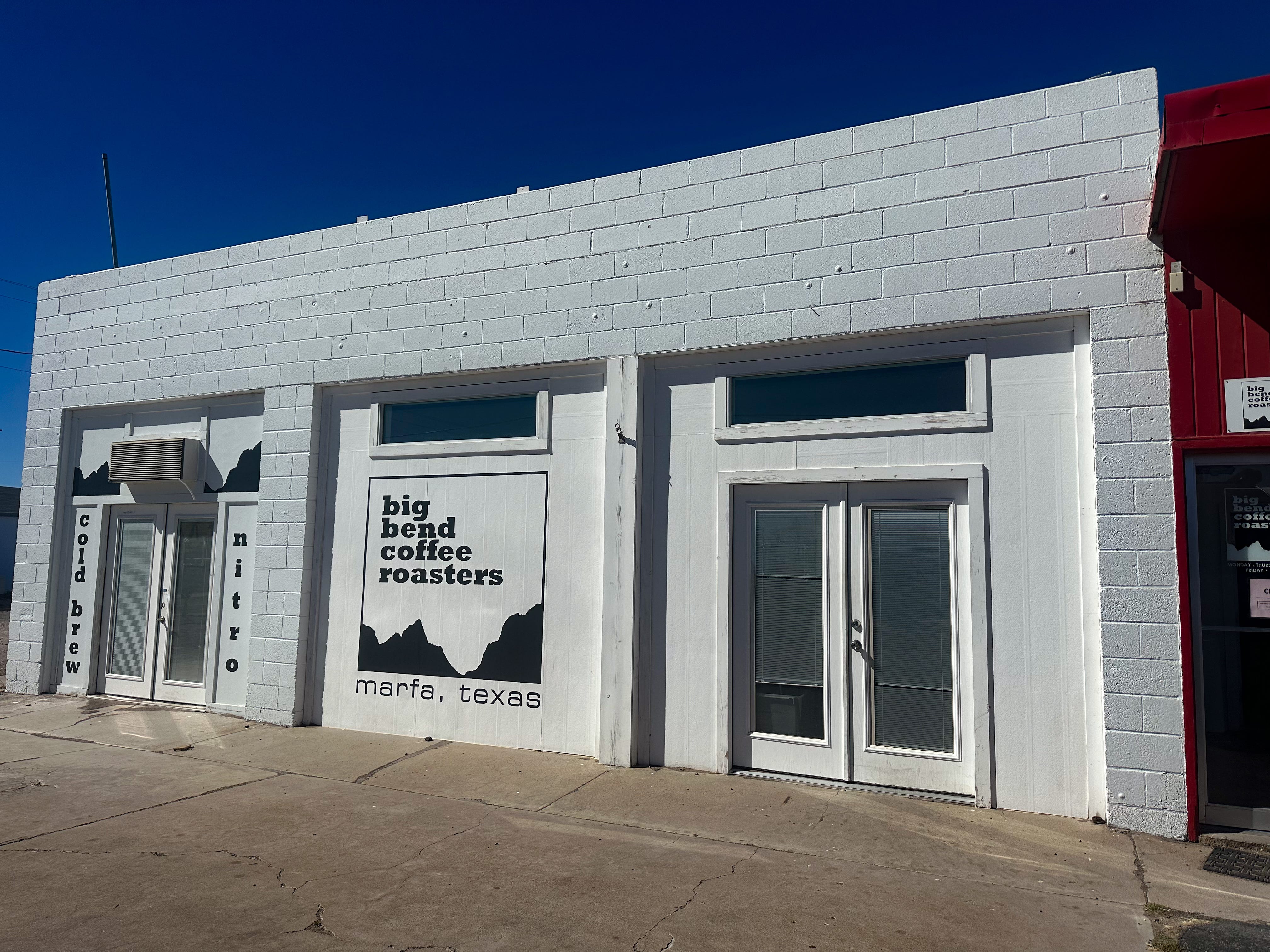
It turned out to be the owner, Joe Williams, and after he ended his phone call he explained that the sign in the door was a holdover from the early pandemic days. He asked what we were looking for, and when I said we hoped to buy some beans, his response — “A ton or a pound?” — suggested the scale of his operation (5,000 pounds of beans leave the place every week, much of it destined for regional retailers). He welcomed us in, and gave us an impromptu tour, including opening bin after bin of freshly roasted beans, showcasing a dauntingly diverse array of roasting techniques, bean types, and countries of origin. An evangelist for mellow, low-acid coffee, he asked what we usually drink and then recommended several options. (I should point out that while we are not coffee fanatics, Leslie and I travel with a bean grinder and French press in our van’s galley, so we have opinions.)
Well after official closing time, we left BBCR with one-pound bags of three different types of beans, which lasted us long past the end of the trip. The coffee we brewed with them was delicious.
From Marfa, we drove east to the town of Marathon, and then beelined south to the park and the campsite we had reserved. Big Bend is unusual among national parks in that it offers both traditional developed campgrounds and boondocking sites it calls “primitive roadside campsites.” These are located off unpaved roads and consist of nothing more than a level-ish gravel pad on which to park. Plus what we initially thought was a steel bear box for food storage. In the Chihuahuan desert, it turns out, they’re not to keep food safe from bears, but from javelinas.
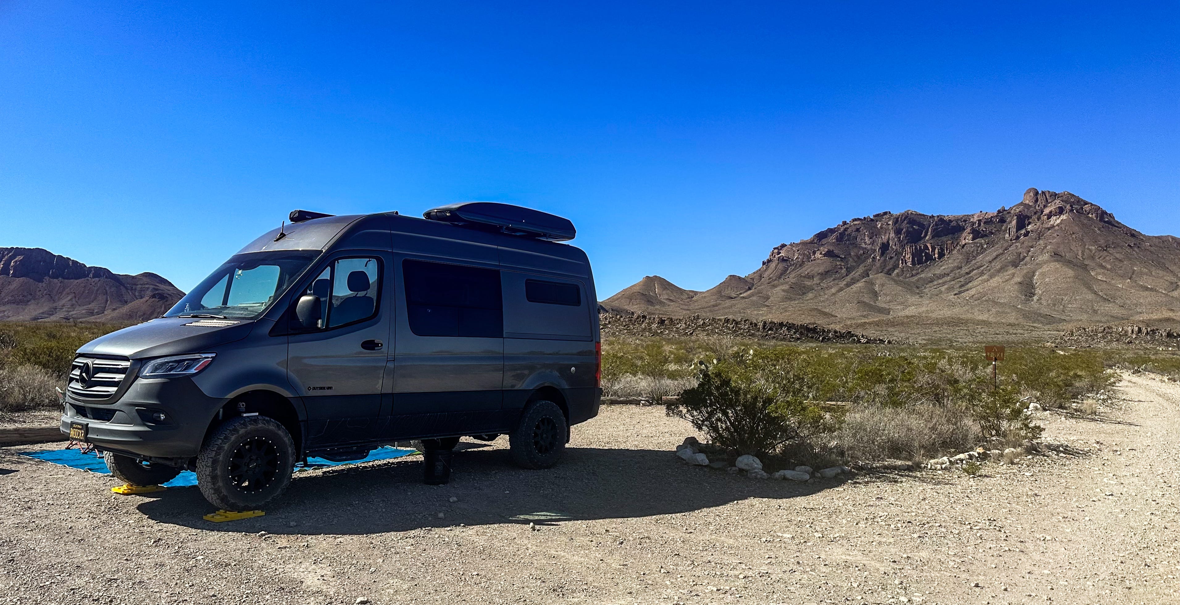
Our site was a mile down a dirt road, and although the turnoff was only 2 miles from one of the busy park visitor centers, our camp offered such silence and solitude that we could have been in the middle of nowhere. Thankfully, the weather had turned springlike: The wind died, and the temperature warmed to the point we could wear shorts during the day and leave the van doors open in the evening.
We spent four nights there. During the days, we explored the park’s geographic and ecological diversity: The desert washes, with their agaves, yuccas and cacti; the forested Chisos Mountains, a sky island in the park’s heart; the Rio Grande River corridor along the southern border; the deep Boquillas and Santa Elena canyons there, carved through massive limestone by flowing water. We met some new birds — Big Bend is famous for its avian diversity, a place where many species at the northern edge of their range mingle with others at the southern end of theirs — and learned new things about familiar ones. (The mating call of a greater roadrunner, for example, sounds much like the cooing of a white-winged dove.)
The border between the U.S. and Mexico is a palpable presence in the region even when you cannot see it. We repeatedly passed through Border Patrol checkpoints as we drove the quiet rural highways of southern New Mexico and West Texas, and Big Bend park literature cautions against purchasing trinkets from peddlers who cross the river from Mexican villages and set up shop along park roads and parking lots. The federal government regards the items, exported without a permit, as contraband and promises to confiscate them.
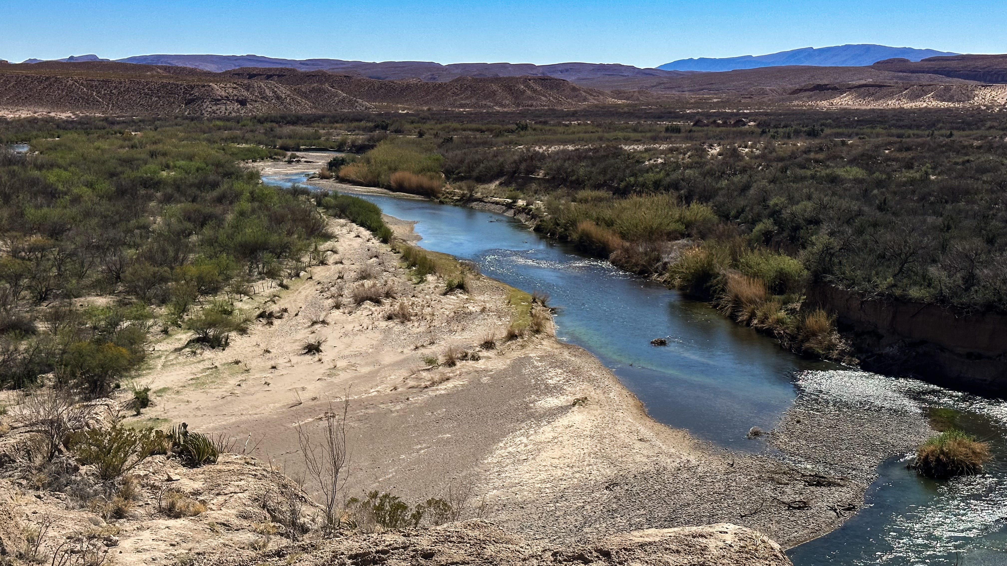
There’s an official port of entry where a bridge connects the park’s Rio Grande Village to Boquillas del Carmen, a town on the other side of the river, and many park visitors use it. Some locals do not: While we were hiking near Boquillas Canyon, we watched a couple of guys on horseback casually lead a string of horses splashing across the river from the park into Mexico, as if the Rio Grande were just another lazy stream instead of an international border and the focus of considerable political angst in two nations.
But the border is more of a concept in Big Bend country than the harsh reality it is elsewhere. There are no walls, no fences, no armed Immigration and Customs Enforcement agents — just a shallow river running gently through a wild desert. Like so many other places on our trip, it was a landscape where a traveler could become lost in time.
Coming in Part 4: The long and winding road home.
Love this, John. Nostalgic for me. I know that land well and love it. What's next?
Hi John, Once again I was transfixed with all your information about the places you and Leslie visited. Bravo. I even had to look up what a Javelinas was...never heard of them before and they are quite interesting for sure. Take care and keep sharing your stories and wealth of knowledge.
Jill