


Pueblos Past and Present
Part 2: Wonders of archaeology and geology

Like many of New Mexico’s 19 Indigenous pueblos, Laguna Pueblo is visually defined by its old Catholic church, Mission San José de Laguna, a striking and much-photographed adobe edifice completed in 1701. These large Spanish-era churches tend to loom over their surrounding communities, reinforcing with physical mass the spiritual and cultural domination the colonizers wielded over over the native population.
Five of the New Mexico pueblos even bear the names of the Catholic saints for which their mission churches were named — Santa Ana, San Ildefonso, Santo Domingo, Santa Clara and San Felipe — not those of the Indigenous people who were living there long before the missionaries showed up. There is belatedly some pushback against this, with the people of Santo Domingo Pueblo, for example, recently changing its name to “Kewa Pueblo” in some official references.
The somewhat confusing pattern of pueblo nomenclature reflects the tangled history of uneasy and at times violent interactions between Indigenous inhabitants of the region and the Euro-American explorers, missionaries and settlers who began arriving in the late 1500s. In fact it seems linguistically odd to refer to the settlements as pueblos at all, given that “pueblo” is a Spanish word that refers variously to a type of communal building complex, an individual village, and a tribal administrative unit that may include multiple villages. It is, however, the formal designation for these places in both Indigenous and U.S. government usage, so I’ve resigned myself to its use in my own writing.
Laguna was the third inhabited pueblo my partner Leslie and I visited on our April journey through Arizona and New Mexico; the first two, Zuni and Acoma, were the subject of the first part of this two-part account of our travels.
In Laguna, we drove narrow streets up the hill where the church is located — the highest point in the village, of course — and went inside to find a spectacularly well-preserved example of a 17th century Spanish mission. Like most of them, it is long and narrow, its width constrained by the length of massive roof-supporting pine or fir logs that could be felled, trimmed and carried by hand to the building site from the nearest source of timber, which in arid country was often on the wetter slopes of mountains 20 or 30 miles away.
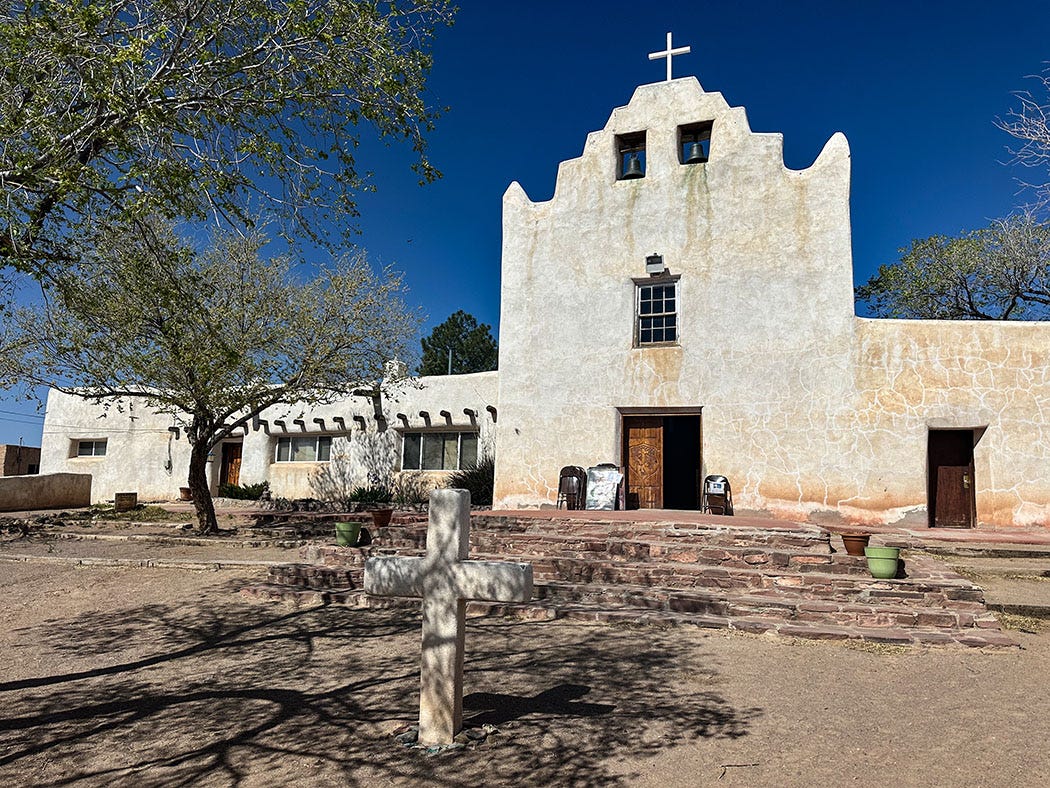
It is difficult to overstate the amount of labor, willing and not, it took to build these monuments to Catholic faith in a land and time mostly without wheels or machines. Onerous forced-labor projects such as those, along with wanton cruelty and disregard for Indigenous values, customs and beliefs, led to what historians refer to as the Pueblo Revolt of 1680, a coordinated and violent revolution against occupation that drove the Spanish out of New Mexico for 12 years.
Don’t call them “ruins”
From Laguna we headed for one of our favorite small towns in New Mexico, Madrid, where we visited shops and galleries, and camped for the night in a Hipcamp site adjacent to the town’s quirky cemetery, where we also stayed last year during our adventures along the Santa Fe National Historic Trail.
From there we headed northwest, roughly following the route of the Old Spanish National Historic Trail — a commercial trading route that linked Santa Fe, New Mexico, to Los Angeles, California, in the 1830s and 1840s — toward the Colorado border. In the small Animas River valley town of Aztec, just east of Farmington, we stopped at Aztec Ruins National Monument to visit one of the most spectacular ancestral Pueblo villages in the Southwest.
Its name is doubly unfortunate. To explain, I will quote from a very helpful guidebook by Gian Mercurio and Max Pechel.
Although it is called “Aztec Ruins,” it was named by early settlers who believed that it was built by the Aztecs. Actually it was built by the ancestral Pueblo people hundreds of years before the Aztec Empire existed. Out of respect for their descendants, the Pueblo, Hopi and Zuni peoples of today, we no longer refer to the sites as “ruins.” The descendants believe that they are sacred places still occupied by the spirits of the people who lived here. They are the “footprints” of their ancestors’ migrations through the land.
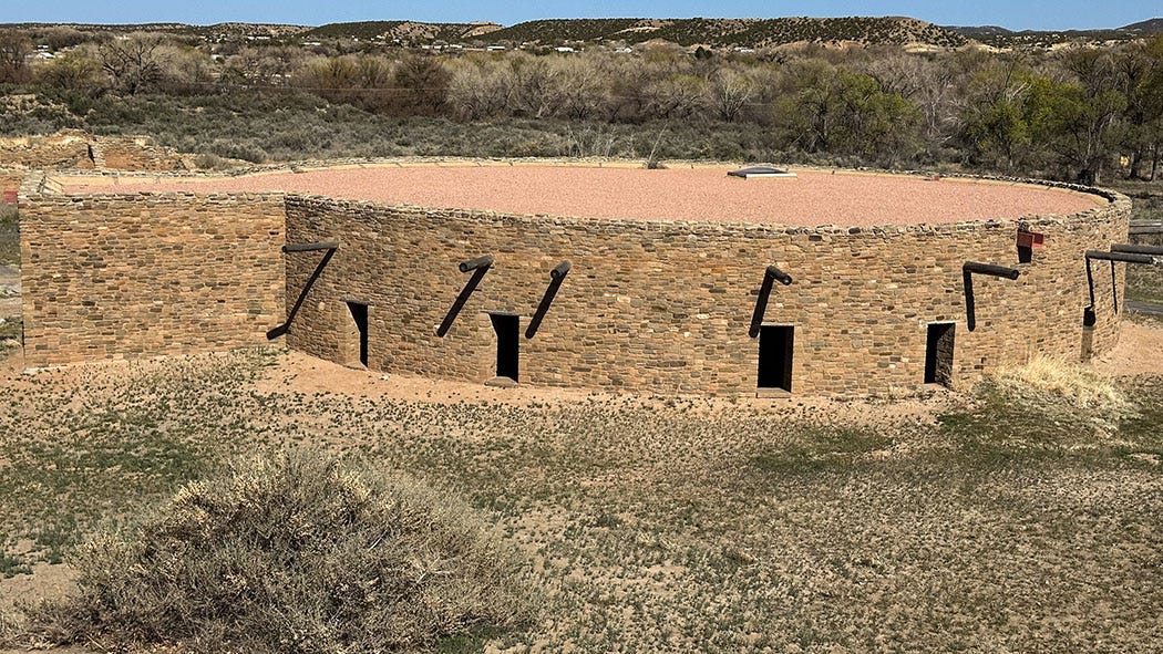
Archaeologists refer to Aztec as an “outlier” of the extensive building complex and regional ritual center preserved at Chaco Culture National Historic Park some 55 miles to the south. Aztec is one of several large satellite villages built and occupied from roughly 1070 to 1300 AD that share construction techniques and building design with the complex at Chaco. (About 10 miles from Aztec, on the San Juan River, Salmon Ruins is another Chaco outlier, and we visited it later in the trip.)
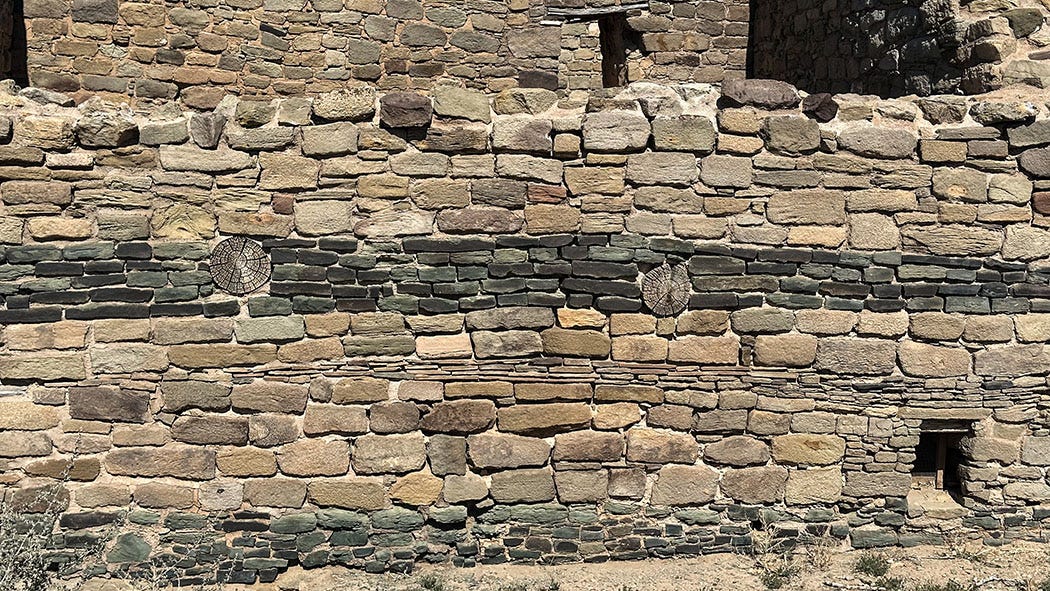
One of the distinguishing features of Aztec is its reconstructed Great Kiva, a spectacular ceremonial and sacred space, and the only restored structure of its kind in the United States. Most ancestral Pueblo settlements contained kivas, but this one is enormous: 41 feet across, with 16-foot-tall stone and wood pillars inside the large circular room supporting a roof weighing 95 tons. It was excavated in 1921, and reconstructed by a team of engineers and archaeologists in 1934.
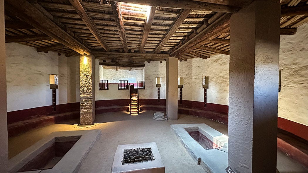
A self-guided interpretive trail leads visitors around and through the Great Kiva and other ground-floor rooms. The walls stand three stories high in some places, and much of the intricate masonry is original.
Aztec is one of those sites that just a few decades ago would have been referred to as the home of the Anasazi, who “mysteriously” vanished from the area around 1300. Today, however, archaeologists are paying attention to the oral histories of modern Pueblo people, and seeking to develop a theory of settlement patterns that reflects both scientific evidence and Indigenous knowledge. Today’s version of the story recognizes that there was a long period of multi-generational migration that generally saw inhabitants moving from the northern part of the Four Corners region to more fertile and well-watered areas in the south, where their descendants live today.
Here's how Octavius Seowtewa, from Zuni Pueblo, described that history in an essay in a recent issue of Archaeology Southwest Magazine:
Zuni people have important connections to the ancestral places we stopped during our migration, including the Mesa Verde region. Our ancestors are still present in all those places. The idea that these sites and landscapes are abandoned is wrong. Pueblo people, Zuni people, did not disappear. We lived in places across Mesa Verde and across the Southwest. When it was time to migrate, we went out on the landscape to seek the next place. For Zuni people, we were searching for the Middle Place — and found it where the Pueblo of Zuni is today ... When we visit the ancient homes and places, we pay respect to our ancestors.

Phantasmagorical geology
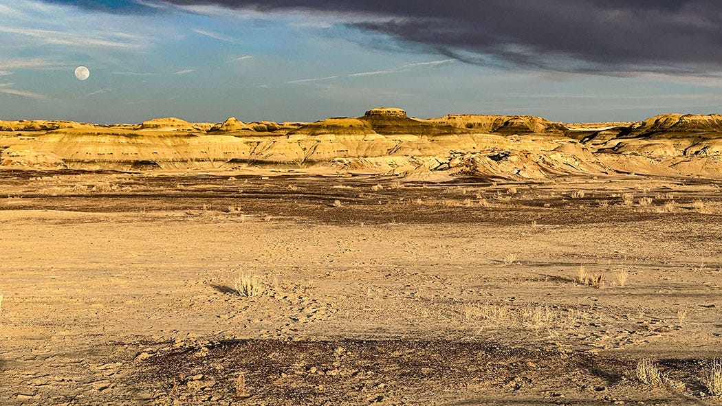
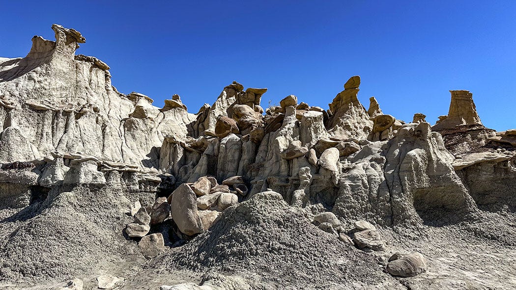
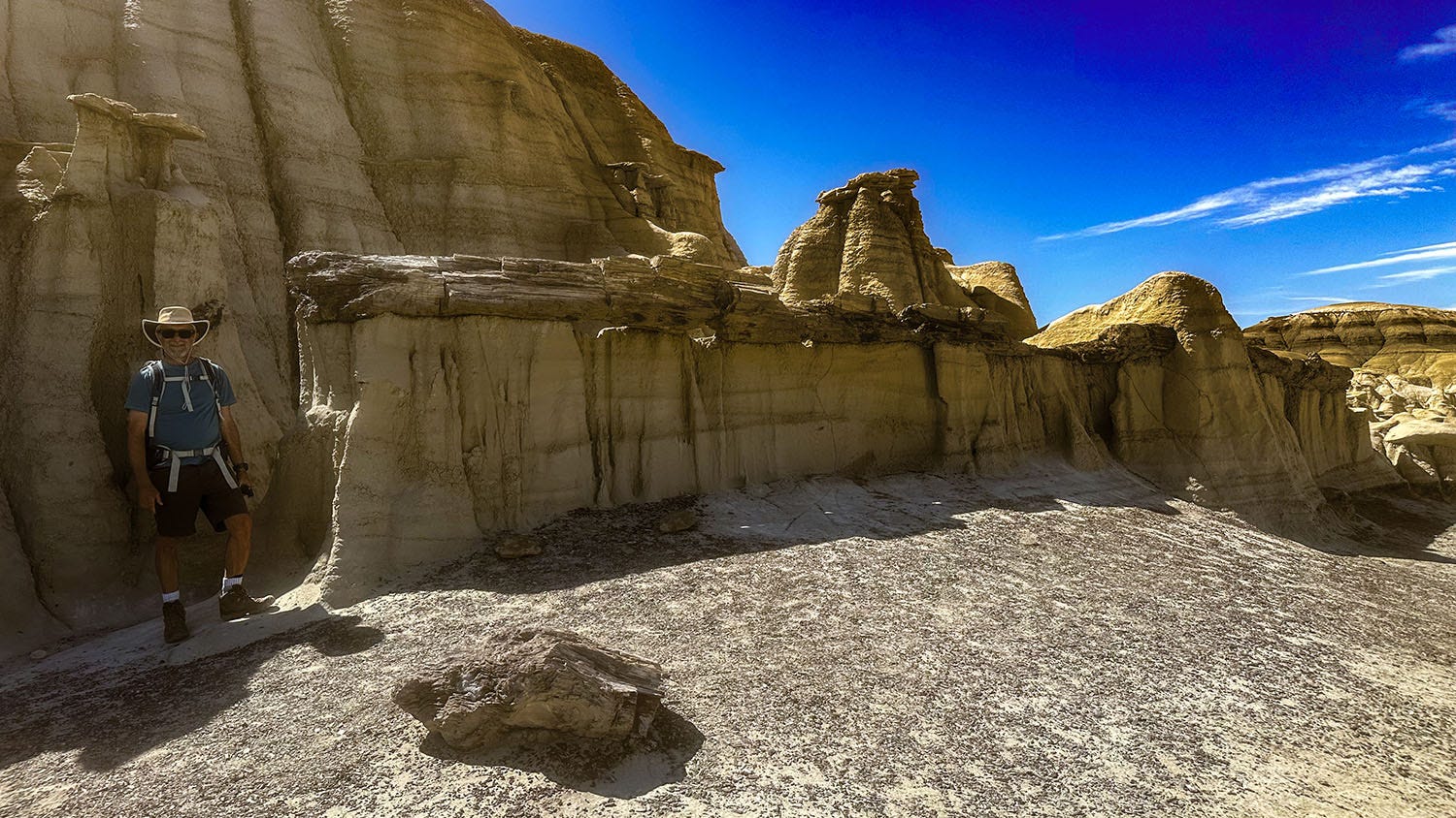
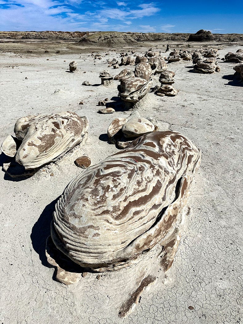
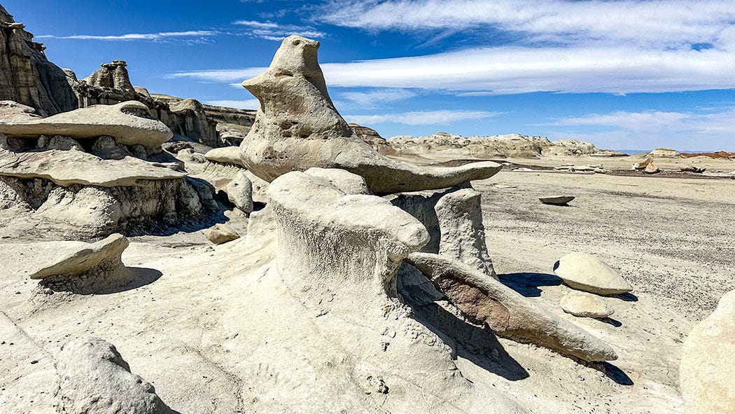
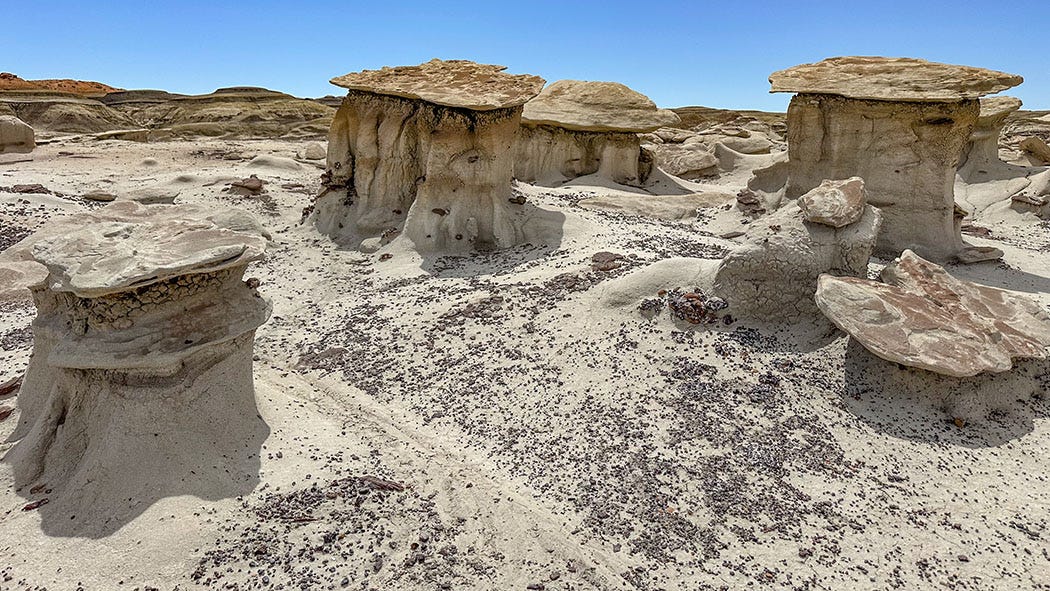
From Aztec, we headed south on a county road, traded pavement for gravel, and made our way to the edge of the Bisti/De-Na-Zin Wilderness Area. Also known as the Bisti (BIS-tie) badlands, the area is a geologic wonderland of bare, eroded sedimentary rock: Layers of shale, sandstone, mudstone, siltstone and coal form colorful, fantastical — nearly hallucinogenic — shapes and textures.
The area gets its name from the Navajo language: Bisti means “a large area of shale hills” and De-Na-Zin means “cranes.” The wilderness is federally owned but is surrounded by lands of the Navajo Reservation, and although we saw no cranes there we saw plenty of shale.
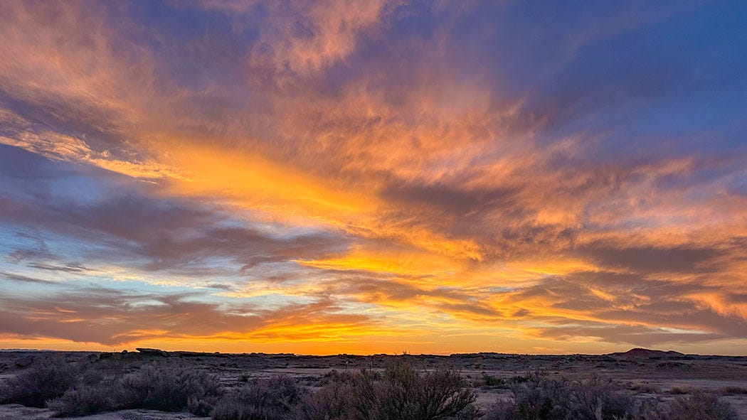
We followed the unpaved road to a signed gravel trailhead parking area, although there are not any maintained trails in the badlands. The lot held a handful of vehicles when we arrived in late afternoon, and although there is no developed campground or much in the way of facilities there — a shade structure over a picnic table, vault toilets along the access road a hundred yards away — the Bureau of Land Management keeps it clean and is fine with people boondocking there as long as they practice leave-no-trace camping. So we did. We had a few neighbors, but they were mostly quiet and we did not mind. The insanely gorgeous sunset that night compensated for the lack of solitude.
The next morning, hoping to beat the heat, we set off on a looping 5-mile hike through some of the most striking scenery in the Four Corners region, which is saying a lot. With no signs, mileage markers or developed trails to follow, we relied on a downloaded track from the Alltrails GPS hiking app to find our way.
I could try to describe in detail what we saw — stone eggs, chocolate hoodoos, petrified trees, crumbling mountains of brittle red stone — but it will be more economical to post this gallery of photos. I could also try to detail the geologic processes that produced such a landscape, but I recommend the New Mexico Bureau of Geology’s overview for those who wish to dig deeply into that topic. I’ll just say that when those layers of badlands sediment were laid down, dinosaurs roamed the Earth and this part of the Four Corners region was the swampy coastline of an ancient sea.

Hopi Land
After a second night in Bisti, we headed back toward Farmington to visit Salmon Ruins, a Chaco outlier similar to Aztec Ruins. Owned by the nonprofit San Juan County Museum Association, Salmon (pronounced SAL-mon) is named for the family that owned and protected it from looters and vandals for many years. It is smaller and not as well preserved as Aztec, but has its own stories to tell about the rise and eventual demise of Chacoan influence throughout the region, as well as its role in the great migrations of the Pueblo people.
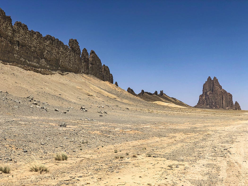
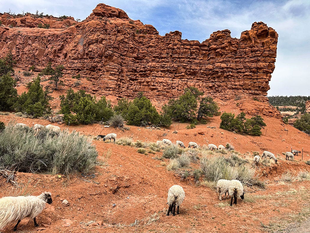
From there we headed to the homeland of some of those who migrated from the northern pueblos between roughly 1100 and 1400. The scenic route took us past Shiprock, a landmark in northwestern New Mexico that is the neck of an ancient volcano still connected to the dikes of hardened lava that fed it when it was active, and then over the Chuska Mountains on the Arizona border, where grazing Navajo sheep and goats briefly blocked our way.
Some 15,000 Hopi live in 12 villages distributed across three mesas in the heart of a 1.5 million acre-reservation, which is entirely surrounded by the much larger Navajo Reservation (17.5 million acres and more than 175,000 residents). Our destination was Second Mesa and the Hopi Cultural Center, which operates a small motel and restaurant there. We had booked a room for two nights, and had arranged for a licensed Hopi tour guide to lead us on a day of exploration.
We met Bertram Tsavadawa at 9 the next morning near the mouth of a canyon about 20 miles from the Cultural Center. So did another couple, who turned out to be among our neighbors at the motel. Our small caravan followed Bertram down 3 miles of dirt road into the canyon, and parked in an alcove next to a looming wall of sandstone.
The rock was liberally covered with Hopi petroglyphs, and for the next three hours Bertram led us to one panel after another, explaining what he and tribal elders believe the spectacular assortment of images represent: clan symbols, astronomical alignments, accounts of creation and migration, tools to chart solstices and equinoxes by the movement of light and shadow.
Bertram does business as Ancient Pathways Tours, and has been guiding for about two decades; his clients have included photographers, researchers, journalists and anthropologists. A member of the Corn Clan, he grew up in his family’s compound on the plaza in Old Oraibi, a village on Third Mesa that is believed to have been inhabited since 1100.
He said it was OK for us to photograph the panels, but asked that we not post the images on social media, a request that I am honoring. Technically non-tribal members are not supposed to leave public highways and trespass on tribal land without a native guide, but outsiders routinely ignore this, and such precious cultural artifacts are sadly vulnerable. Revealing their location via online platforms would just increase the odds of vandalism.
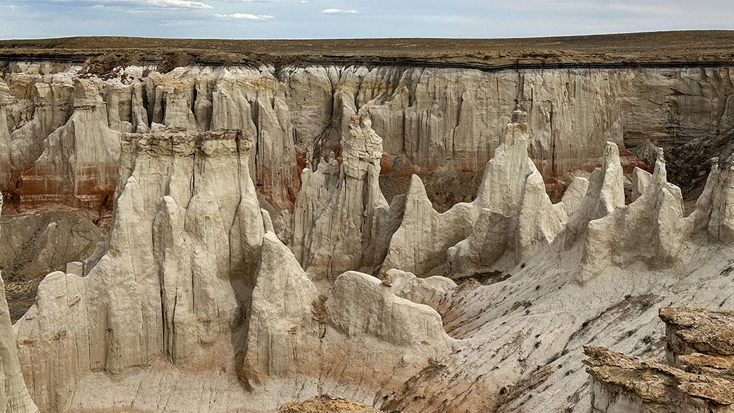
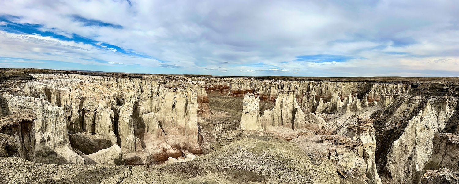
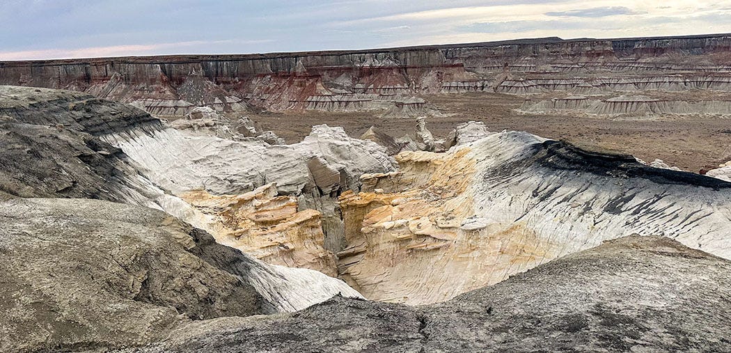
From the petroglyph canyon, we followed Bertram to a nearby overlook, located on private land, providing vistas of one of the most spectacular natural features of the Hopi Reservation: Coal Mine Canyon.
It really needs a better name. Not only is there no coal mine there (although there are thin beds of poor-quality coal) but the canyon walls are spectacularly beautiful, the vistas mind-boggling. It’s National-Park-caliber scenery of fantastically eroded sedimentary layers in white, red, purple and gold.
After a lunch break at a nearby travel plaza, the other couple left to continue their journey, but Leslie and I returned with Bertram to the canyon. We climbed into his car and spent the next couple of hours traveling from one overlook to another as Bertram described the geological history of the landscape and spoke about the occasional cultural clashes that grow out of the presence of Navajo inholdings on what is supposed to be Hopi land.
By the time our tour ended, it was coming on to evening. Although our senses were somewhat overwhelmed, we felt privileged to have spent the day with someone so generous with his knowledge, insights and perspective. Before we parted, Bertram presented us gifts — a crystal pendant for Leslie, an obsidian amulet for me, native blue corn seeds for us both — and in lilting Hopi pronounced a blessing upon the next stage of our journey: that we be safe and find fulfillment in our future travels.
It’s working.


John, I can't say it enough, WOW! What a great trip ending with a day with Bertram and those photos of Coal Mine Canyon. What a spectacular site. It's going to be hard to find another area as rich and fascinating for you and Les. Jill
It is always such a treat to read your travel stories! How wonderful to hear Bertram's blessing is working! Looking forward to the next installment.