


Petroglyphs and Petroleum
Oil boom imperils world's largest outdoor art gallery

Through a quirk of geography and transportation engineering, nearly all of Utah’s iconic landscapes, those well-loved national parks of the redrock country, lie to the south of Interstate 70.
South of that broad east-west ribbon of pavement and its steady flow of high-speed truck traffic, visitors from around the globe flock to the famed “Big Five” attractions: Arches, Capitol Reef, Canyonlands, Bryce and Zion national parks, which are overrun during the peak tourism season.
It’s a different story, however, north of the interstate. There’s some spectacular scenery there as well: The lovely and lonely reaches of the Green River in Desolation and Gray canyons, the towering Book Cliffs along the edge of the Tavaputs Plateau, the forested alpine summits of the Wasatch Plateau. But the region, bounded generally on the north by the Uintah Mountains, is not as well known or as heavily visited as the celebrity sandstone monuments to the south.
What that lonely northern region does have in abundance is fossil fuel deposits, as reflected in some of the local place names: Carbon County, Carbonville, East Carbon. Coal extraction is falling there, as it is everywhere else the West, but the Uintah Basin, in particular, is in the midst of an oil and gas boom.
There’s one other resource that largely empty region has in abundance: ancient archaeological sites, including some of the most spectacular rock art in the world. And in a narrow, remote canyon northeast of the old railroad town of Price, champions of those two very different types of resources — petroglyphs and petroleum —are headed for a showdown.
Artwork of the ancients
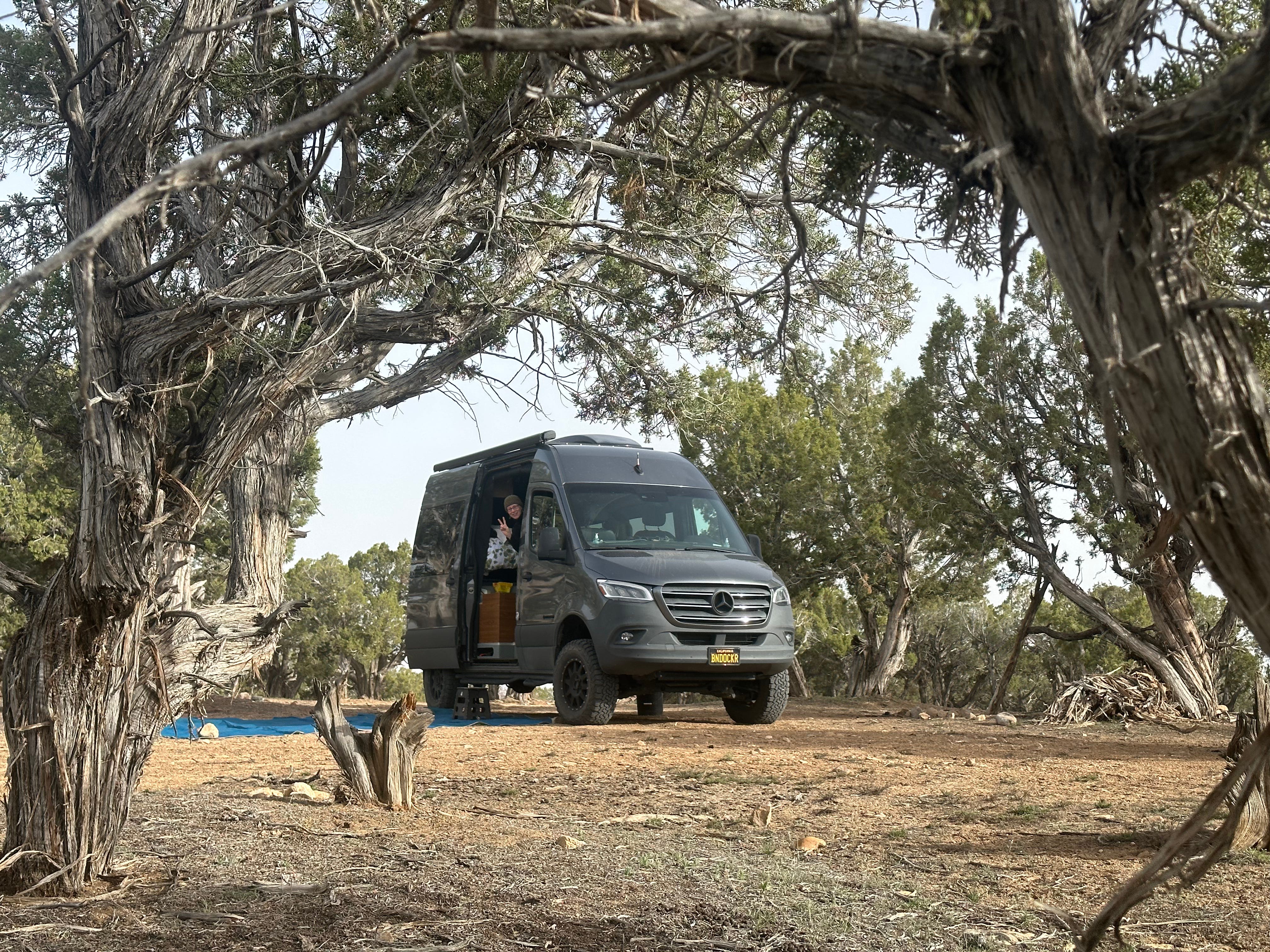
Southeast of Price, a narrow two-lane rural road follows Nine Mile Canyon into the Patmos Mountains. Leslie and I traveled into that country during our April-May road trip in Next Chapter, which I wrote about last month, battling fierce winds as we headed north after our visit to Capitol Reef. The night before our journey into the canyon, we camped in a pinyon-juniper woodland, protected from the worst of the gusts by ancient, gnarled trees. Judging by the abundant deer scat and numerous rock fire rings, the boondocker area is a popular autumn haunt of hunters, but on this spring evening we were alone.
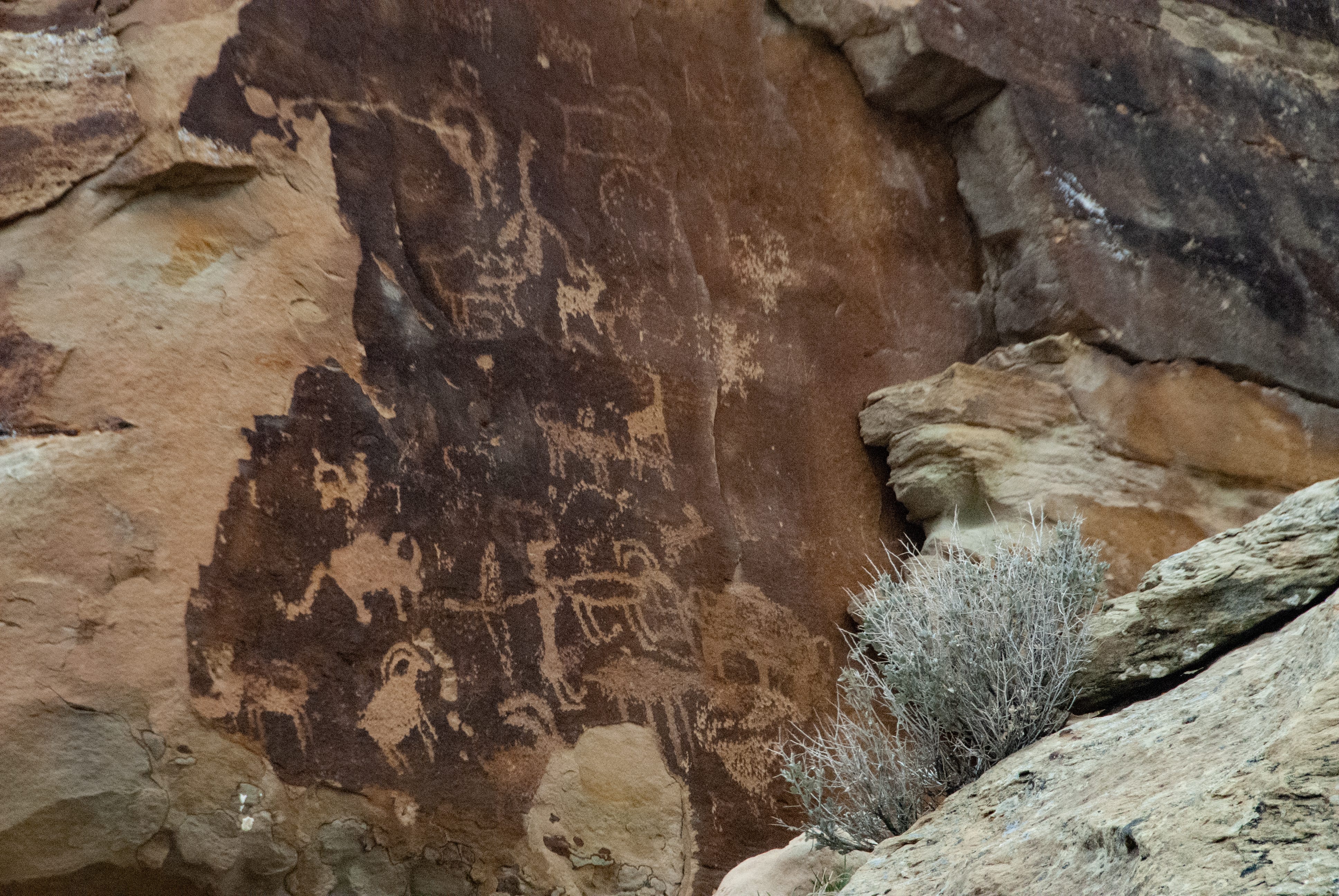
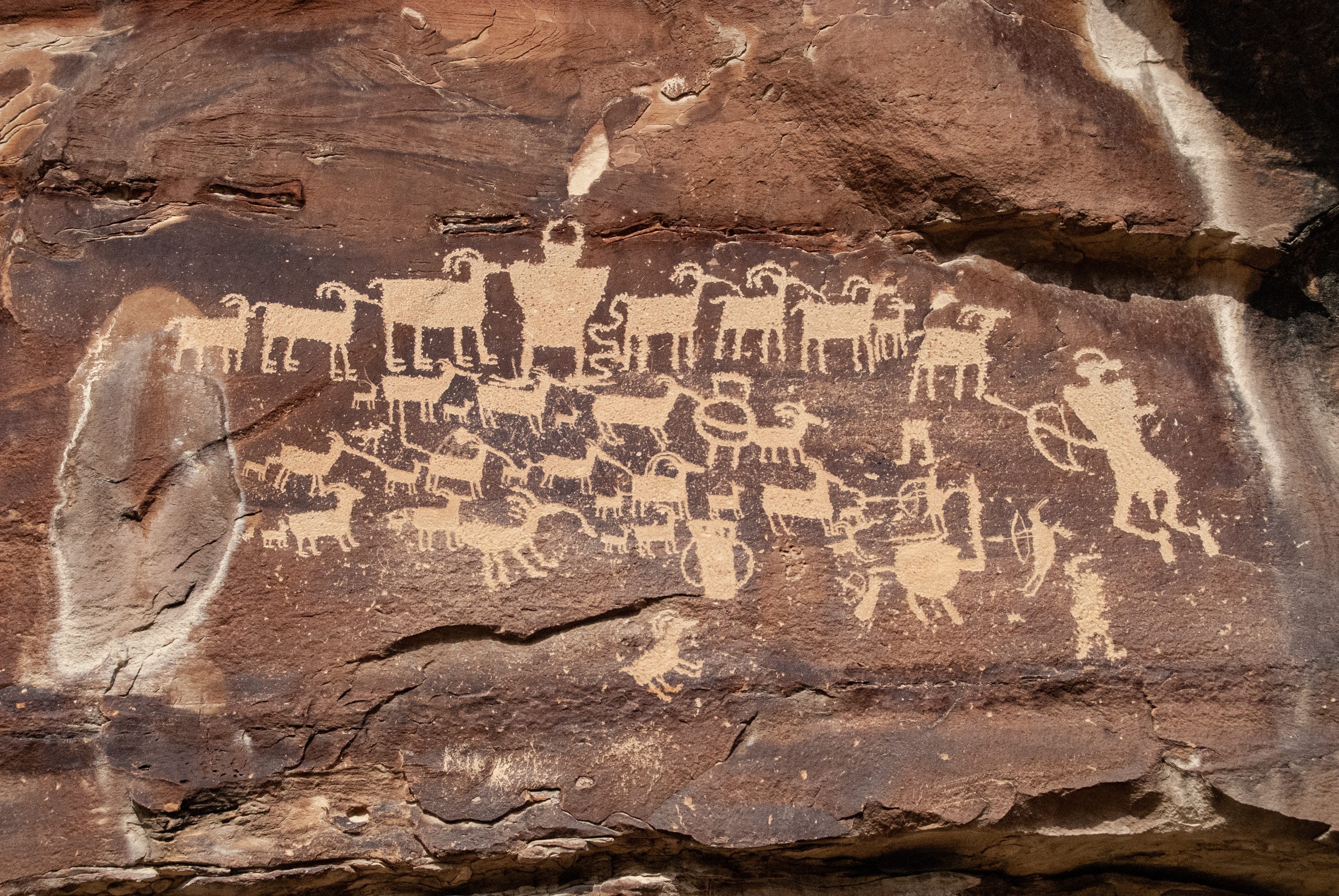
It was cold and overcast the next morning as we set off on Nine Mile Canyon Road, which is not 9 miles long but actually stretches for 46 miles (the origins of the numerical mismatch are unclear). It winds along Soldier Creek, past old homesteads and scattered gas wells, climbs over a divide (blanketed in snow the day we were there), and then descends into an increasingly spectacular canyon carved by Nine Mile Creek. The sandstone walls are liberally stained by desert varnish, a mineral patina created by microbial action, and ancient artists chiseled, carved and pecked thousands of petroglyphs into it over the course of many centuries.
The canyon has been a travel corridor through the rugged country for 8,000 years, and the artwork reflects the contributions of at least three distinct cultural groups: hunter-gatherers of the Archaic period (7000-500 BC), the agriculturalists of the Fremont period (roughly 300-1300 AD), and later groups such as the Ute, Paiute and Shoshone (1600s and 1700s), who added painted images to the assortment. The artworks line the canyon for more than 20 miles, and include some of the most dramatic and artistically impressive panels found anywhere in the Desert Southwest, a linear gallery of animals, humans, geometric figures, hunting scenes and mystical beings that is staggering in its diversity and profusion.

In the 1880s, soldiers in the all-Black 9th Cavalry transformed the Native American trails through the canyon into a road suitable for horses, wagons and stagecoaches, linking the newly built Fort Duchesne to the railroad hub near Price. The road remained rugged dirt, serving mainly farms and ranches, until 2013, when it was widened and paved so trucks and heavy equipment could reach a gas field being developed on nearby mesa tops.
There’s some truck traffic in the canyon now, but for the most part we found it quiet and empty. There is some basic signage at favored petroglyph viewing sites and a few pullouts for parking, but the remote canyon remains isolated and primitive, and we encountered only a handful of other visitors during the hours we spent exploring it.
That could all change if a proposal submitted recently by local government officials to the U.S. Bureau of Land Management wins approval.
A road paved with bad intentions
As we left Nine Mile Canyon, we took a shortcut through a side canyon toward the small town of Myton. The route passes through Gates Canyon along 5 miles of steep, rocky, twisty, unpaved track that links the pavement of Nine Mile Canyon Road with the pavement of state Highway 191. The narrow road was relatively easy driving for Next Chapter, but utterly unsuitable for the huge insulated double-tanker rigs that haul the Uintah Basin’s waxy crude oil — a paraffin-rich substance that’s a semi-solid, not a liquid, at temperatures below 110 degrees — from the drilling rigs to the heated rail cars that haul it to distant refineries.
Oil producers would like to change that. The Duchesne County Special Service District #2 — a tiny local agency charged with road construction and maintenance responsibilities in a county with fewer than 20,000 residents — has asked the BLM, which manages the federal lands in and around Nine Mile Canyon, to approve a plan to straighten, widen and pave the rugged Wells Draw Road through Gates Canyon. Linked up with the Nine Mile road, the resulting all-asphalt route between the oil fields and the rail head near Price would shave a few miles off the existing highway transportation route, saving the oil producers money and decreasing the odds that a theoretical traffic delay on Highway 191 might cause the crude in the unheated tankers to congeal, with ruinous effects. By the calculations of local leaders, this could mean a huge truck barreling through Nine Mile Canyon every three minutes, as many as a thousand vehicles each day.
It’s bad enough that straightening and paving Wells Draw Road would mean blasting cliffs, filling draws and otherwise wrecking the natural landscape. More significantly, the traffic itself would fundamentally change the context of the irreplaceable artwork in Nine Mile Canyon, and destroy the experience of its mystery and beauty. And it would do this in service of an industry likely to collapse within a generation, either because market demand for its product withers or because the finite resource is exhausted. The boom and bust economic model has a long and bitter history across the West.
That this tradeoff is even on the table for discussion underscores one of the abiding tensions underlying public-lands policy debates throughout the West. The American people own those public lands — albeit they are often lands that were violently wrenched from their original inhabitants — but parochial local interests have historically exerted undue sway over their management. Another common tension is the inequitable distribution of the costs and benefits of exploiting those lands. Duchesne County, for example, derives tax revenue from the Uintah Basin extractions and supports the paving project. Neighboring Carbon County, home to Nine Mile Canyon and a growing tourism economy based on enjoyment of its archaeological wonders, would derive no economic benefits from the oil traffic but would bear the cost of the canyon’s desecration. County leaders there oppose the paving plan, as does a coalition of local communities and advocates.
It remains to be seen which argument the BLM will find more compelling. The agency has long struggled to balance demands for extractive or destructive uses of the land it manages — mining, logging, grazing, offroad vehicle travel — with competing priorities, such as passive recreation, cultural resource protection and wildlife habitat conservation. But once you have spent time in the silence of the canyon, examining intricate assemblages of art etched into stone more than a thousand years in the past, it is impossible to come down on the side of an economically tenuous extractive industry with no real future.
Your travels inform and amaze. You keep adding to my/our bucket list!
Very interesting. The petroglyphs are stunning. I pray they are not destroyed for greed.